 Master Plan of the environmental threats of a Hotel construction site - Ikos Odissia Corfu - Greece.The construction of the "Ikos Odissia" Hotel in Corfu, Greece, marks an exciting development for the tourism industry in the region. However, every construction project, regardless of its significance, brings with it a set of environmental threats that must be addressed responsibly. This master plan outlines the key environmental concerns associated with the construction of Ikos Odissia Hotel and provides a comprehensive strategy for mitigating these threats. |  Industrial Heritage Master PlanGuardians of the past, industrial sites testify to the ordeals and exploits of those who worked in them. Industrial sites are important milestones in the history of humanity, marking humanity's dual power of destruction and creation that engenders both nuisances and progress. |  Shaded Relief Mapping |  Gratini Dam - GreeceUnderstanding the impact of dam-triggered land use/land cover change |  Expropriation Orthophoto MapThe dynamics of urban expansion and its impacts on land use/land cover change and small-scale farmers living near mining areas. |  Open Pit Mining LandUse ChangesLand use/land cover changes in the mining area of coal fields of Northern Greece. |
|---|---|---|---|---|---|
 Lignite Center of Western MacedoniaLand use/land cover change dynamics analysis in mining areas of Lignite Center of Western Macedonia - Greece. |  Vereggarria Renovation Project - CyprusDrone Mapping Photogrammetry and Orthophoto produce in Vereggarria abandonent settlement in Cyprus. |  Geological Map of Athos Peninsula |  Lignite Deposits in Megalopoli basin |  Traffic Noise PredictionPrediction, Calculation and Mapping Road Traffic Noise in Asteras Vouliagmeni Bungalows and Resort. |  Pm10 EstimationEstimate PM10 concentration due to a large renovation project in Asteras Hotels and Resort (Vouliagmeni - Greece). |
 Open Pit Mining True Orho MappingGeomatics for Rehabilitation of Mining Area. |  Potentiometric SurfacePotentiometric Surface and Water-Level Difference Maps of Selected Confined Aquifers in Northern Greece. |  Geomorphology MappingTerrain cartography as an essential aspect of physical geography. |  Geologic MappingGeological Web-Gis of Egnatia Motorway |  Hydrolithology MappingCreation of a Digital Aquifer Permeability Map for the Chalkidiki watershed in North Greece. |  Geologic MappingGeologic Mapping for water quality project. The case of Eleftheres watershed. North Greece. |
 Noise EstimationNoise Estimation Mapping due to large Renovations Project. |  Landfill 3D VisualisationIntergrated GIS, Fuzzy Logic and AHP in modelling Optimum Sites for Landfill Selection. |  Watershed Conductivity and SalinityUrban Watersheds: Geology, Contamination, and Sustainable Development |  Hazard Risk MappingIntergrated GIS, Fuzzy Logic and AHP in modelling Optimum Sites for Landfill Selection. |  Geologic MappingHydrothermal alteration zones detection in Limnos Island through remote sensing. |
Uav Services
Evmolpos provides a wide range of services derived of UAV use, such as aerial photography and video, remote sensing, commercial aerial surveillance as well as various custom applications that can be adapted to the customer’s exact specifications. Evmolpos team has experience in Geographic Information Systems (GIS), global positioning system (GPS) and is qualified in feature extraction, manipulation and provides accurate and orthorectified geo-referenced image data and 3D building models.
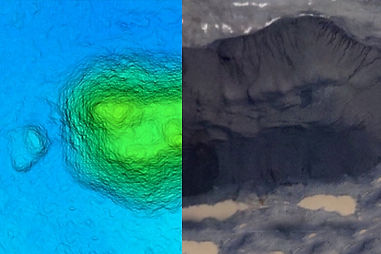
Stockpile volume calculation
During recent years, calculating stockpile volumes has been difficult and expensive. Having considered how dynamic our world is, new techniques and methods should be presented in numerous fields. For example, nowadays there are some different options and methods for stockpile volume calculation depending on time, experience and cost. One low cost method, which recently has tremendous growth, is using UAVs.
Besides mapping and photogrammetric applications, UAVs perfectly complies with the needs for mine engineering and in particular volume computation.

Orthoimage
Reliable UAV systems are constantly used during last year in order to create low cost and accurate land images. But UAV systems are of no use without sophisticated data processing.
Evmolpos team has developed a procedure for UAV project planning based on the user requirements, image accuracy, camera specifification, image overlapping characteristics and flight height. This leads to accurate flight planning determination and true orthoimage creation.

3D Modelling
Structure from Motion photogrammetry with Multi View Stereo provides hyperscale landform models using images acquired from a range of digital cameras and optionally a network of ground control points.
The technique is not limited in temporal frequency and can provide point cloud data comparable in density and accuracy to those generated by terrestrial and airborne laser scanning at a fraction of the cost. Structure from motion is also useful in remote or rugged environments where terrestrial laser scanning is limited by equipment portability and airborne laser scanning is limited by terrain roughness causing loss of data and image foreshortening.
The technique therefore offers exciting opportunities to characterize surface topography in unprecedented detail and, with multi-temporal data, to detect elevation, position and volumetric changes that are symptomatic of earth surface processes. Structure from Motion can be placed in the context of other digital methods.