 Master Plan of the environmental threats of a Hotel construction site - Ikos Odissia Corfu - Greece.The construction of the "Ikos Odissia" Hotel in Corfu, Greece, marks an exciting development for the tourism industry in the region. However, every construction project, regardless of its significance, brings with it a set of environmental threats that must be addressed responsibly. This master plan outlines the key environmental concerns associated with the construction of Ikos Odissia Hotel and provides a comprehensive strategy for mitigating these threats. |  Industrial Heritage Master PlanGuardians of the past, industrial sites testify to the ordeals and exploits of those who worked in them. Industrial sites are important milestones in the history of humanity, marking humanity's dual power of destruction and creation that engenders both nuisances and progress. |  Shaded Relief Mapping |  Gratini Dam - GreeceUnderstanding the impact of dam-triggered land use/land cover change |  Expropriation Orthophoto MapThe dynamics of urban expansion and its impacts on land use/land cover change and small-scale farmers living near mining areas. |  Open Pit Mining LandUse ChangesLand use/land cover changes in the mining area of coal fields of Northern Greece. |
|---|---|---|---|---|---|
 Lignite Center of Western MacedoniaLand use/land cover change dynamics analysis in mining areas of Lignite Center of Western Macedonia - Greece. |  Vereggarria Renovation Project - CyprusDrone Mapping Photogrammetry and Orthophoto produce in Vereggarria abandonent settlement in Cyprus. |  Geological Map of Athos Peninsula |  Lignite Deposits in Megalopoli basin |  Traffic Noise PredictionPrediction, Calculation and Mapping Road Traffic Noise in Asteras Vouliagmeni Bungalows and Resort. |  Pm10 EstimationEstimate PM10 concentration due to a large renovation project in Asteras Hotels and Resort (Vouliagmeni - Greece). |
 Open Pit Mining True Orho MappingGeomatics for Rehabilitation of Mining Area. |  Potentiometric SurfacePotentiometric Surface and Water-Level Difference Maps of Selected Confined Aquifers in Northern Greece. |  Geomorphology MappingTerrain cartography as an essential aspect of physical geography. |  Geologic MappingGeological Web-Gis of Egnatia Motorway |  Hydrolithology MappingCreation of a Digital Aquifer Permeability Map for the Chalkidiki watershed in North Greece. |  Geologic MappingGeologic Mapping for water quality project. The case of Eleftheres watershed. North Greece. |
 Noise EstimationNoise Estimation Mapping due to large Renovations Project. |  Landfill 3D VisualisationIntergrated GIS, Fuzzy Logic and AHP in modelling Optimum Sites for Landfill Selection. |  Watershed Conductivity and SalinityUrban Watersheds: Geology, Contamination, and Sustainable Development |  Hazard Risk MappingIntergrated GIS, Fuzzy Logic and AHP in modelling Optimum Sites for Landfill Selection. |  Geologic MappingHydrothermal alteration zones detection in Limnos Island through remote sensing. |

Saline Web-Gis
Representation and analysis of water - related phenomena by Gis Facilitates their management. Gis Applications that are of particular importance to water industry professional are: mapping, monitoring, modeling and maintenance. These four parameters define some of the most important activities for efficient management of water systems.
With the help of the Web-Gis technologies we can realize the full potential of Gis technology in solving water chemistry related problems.
Saline Web-Gis platform supports data chemistry manipulation. This web technology (pure HTML/JavaScript) is beneficial when used by large audience – users who are not willing (or not capable) to install thick client application and when Java Applet is in the way. Saline Web-Gis merges smoothly into all standard web browsers (Firefox, Internet Explorer, Safari, Chrome, etc.). Advanced JavaScript and AJAX is used to provide best user experience.

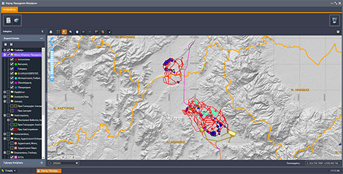
System Architecture
Saline Web-Gis is much more complex system than web viewer because of it's ability to edit spatial data and geometries.
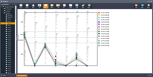
This web application can store, edit, manage, show on map, analyze data from water chemical analyses. The web application analyzes the data and produces a series of diagrams, such as SDurov, Extended Durov, Piper, Stiff, Waterlot, Wilcox, Sar, Ternary and various statistical diagrams.
Result can be plotted or printed.
Saline Web-Gis Editor
Architecture and data structure
Web-GIS platform for implementing Spatial Data
Saline Web-GIS is used to import, export, manipulate and develop various cartographic products. The layer manager includes vector and raster data (satellite images, thematic maps and density maps).
Main functionalities of Saline Web-Gis:
-
Add, edit and delete data from water chemical analyses.
-
Show point data on map.
-
Select data by attributes or perform spatial selection.
-
Produce a series of diagrams (piper, durov, stiff, waterlot, sar, ternary, etc).
-
Print maps and diagrams.