Regional focal mechanisms in the Aegean area determinded by waveform modeling and their Tectonic imp
Focal mechanism parameters of earthquakes with magnitude Mw>5.0 and shallow focal depth (h <40 Km) from Greece and its surroundings have...

Create digital Orthophoto World View II imagery and high-resolution DEM: monitoring environmental im
The expansion of surface coal mining to meet the world’s energy needs must include preplanning for environmental protection and the...

Τhe Cephalonia Transform Fault and its extension to western Lefkada island (Greece)
The central area of the Ionian Islands is dominated by the existence of a major tectonic structure called the Cephalonia Transform Fault...

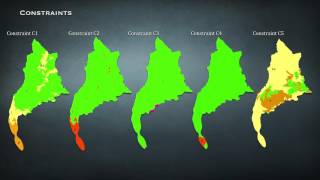
Landslide Hazard Mapping using Gis and Remote Sensing Techniques: The Case of Egnatia highway NW Gre
Landslide hazard mapping is an important tool for disaster management, basic data collection and their management. The landslide hazard...

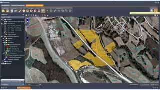
Application of satellite imagery in monitoring the lake Koronia shoreline change (North Hellas)
The lake Koronia, located in central Macedonia, is one of the most important biotope of our country. The ecosystem of the lake is a...