Orthophoto generation using IKONOS imagery and high-resolution DEM. Integration of digital photogram
This project describes a workflow for the DEM extraction from unrectified satellite stereo scenes, its visualization and integration in...

Mce & Fuzzy Modelling of Environmental Suitability for Urban Development of the Kalamata municip
During the last years it has become a common knowledge that urban development is a complicated dynamic process, which involves various...

Uav airborne remote-sensing technologies for lignite open pit mining…
In mining industry, photogrammetry can be used for stockpile monitoring, orthophoto production, highwall surveying, as well as backup...

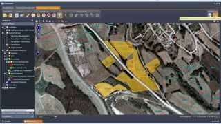
Flood hazard assessment in North Greece using Remote Sensing Data (RS) with Geographical Information
Flooded area and flood hazard assessment in Gallikos catchment area (North Greece) were evaluated using remote sensing (RS) data with the...

Integration of Geographic Information Systems (GIS) and Satellite Remote Sensing (RS) for watershed
The main problems in watershed management are deforestation and the expansion of agricultural land, which together cause soil erosion and...
Lignite Center of Western Macedonia, Greece - Industrial Complex LiPtol
Ptolemaida, the second city of Eordaia province, has been one of the main industrial bases of Greece since the end of the 20th century....

Applications of Remote Sensing and Gis in modeling forest Fire hazard: The case of the wildfires of
Natural disasters such as floods, wildfires and earthquakes usually result in significant human losses and environmental degradation. To...

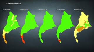
A Gis Based Multi-Criteria (MCE) evaluation system for landfill site selection
Selecting the most suitable site for landfill can avoid any ecological and socio-economical effects. The increase in industrial and...

Create digital Orthophoto World View II imagery and high-resolution DEM: monitoring environmental im
The expansion of surface coal mining to meet the world’s energy needs must include preplanning for environmental protection and the...

Landslide Hazard Mapping using Gis and Remote Sensing Techniques: The Case of Egnatia highway NW Gre
Landslide hazard mapping is an important tool for disaster management, basic data collection and their management. The landslide hazard...